I have heard it said many times recently that people have forgotten how to behave. One theory is that the relative lack of social interaction during the pandemic has caused some to forget their social skills. Personally, I think there’s more to it than that. Sure, that may be a contributory factor, but I’m more inclined to believe that the pandemic simply exacerbated an already existing decline in social etiquette.
Of course, I’m completely aware that I’m growing older and tend to have less tolerance for poor behaviour. Possibly I’m simply experiencing an age-old generational trend of older people believing that younger people don’t know how to behave. Except that it’s not just young people, it’s people in general whose behaviour seems to have degenerated.
This year we felt it necessary to explain to our postgraduate students what was expected of them – I’m not talking about how they should perform academically, but how they should behave socially. Simple things like punctuality, common curtesy etc. All the basic skills that students need and that will allow learning to take place easily in a supportive and inclusive setting. I’ve been teaching in higher education for almost 30 years and this is the first time that our teaching team felt it was necessary to teach our students how to behave.
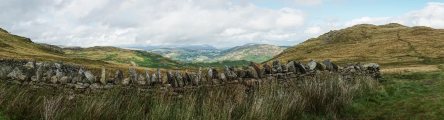
This is a roundabout way of saying that I really shouldn’t be surprised when people I meet on the fells don’t conform to expectations. However, it is exceptional when that does occur because by-and-large, the people I meet out on the fells are lovely. They have a mutual understanding of fell etiquette and enjoy sharing pleasantries. There aren’t many unwritten rules other than “be nice”, but one rule in particular seems to be going out of fashion, that of spending only the required amount of time at a fell summit cairn or trig column as is necessary to touch the highest point and maybe take a photo. Most folk who understand this principle will bag their fell and then walk off a few metres in search of a place to rest and have lunch. Sadly, this is not always the case and recently I have arrived at the highest point of a fell to find a group of walkers sitting on the summit cairn, munching sandwiches, making it difficult to bag and impossible to photograph.
Worse things happen at sea (obviously) but it doesn’t make this any less frustrating.
I’d come up to the Lakes for my regular August visit and since I’d be doing most of my walking in the Far Eastern fells, I’d booked a room at YHA Patterdale rather than my usual haunt at Ambleside.
Tuesday
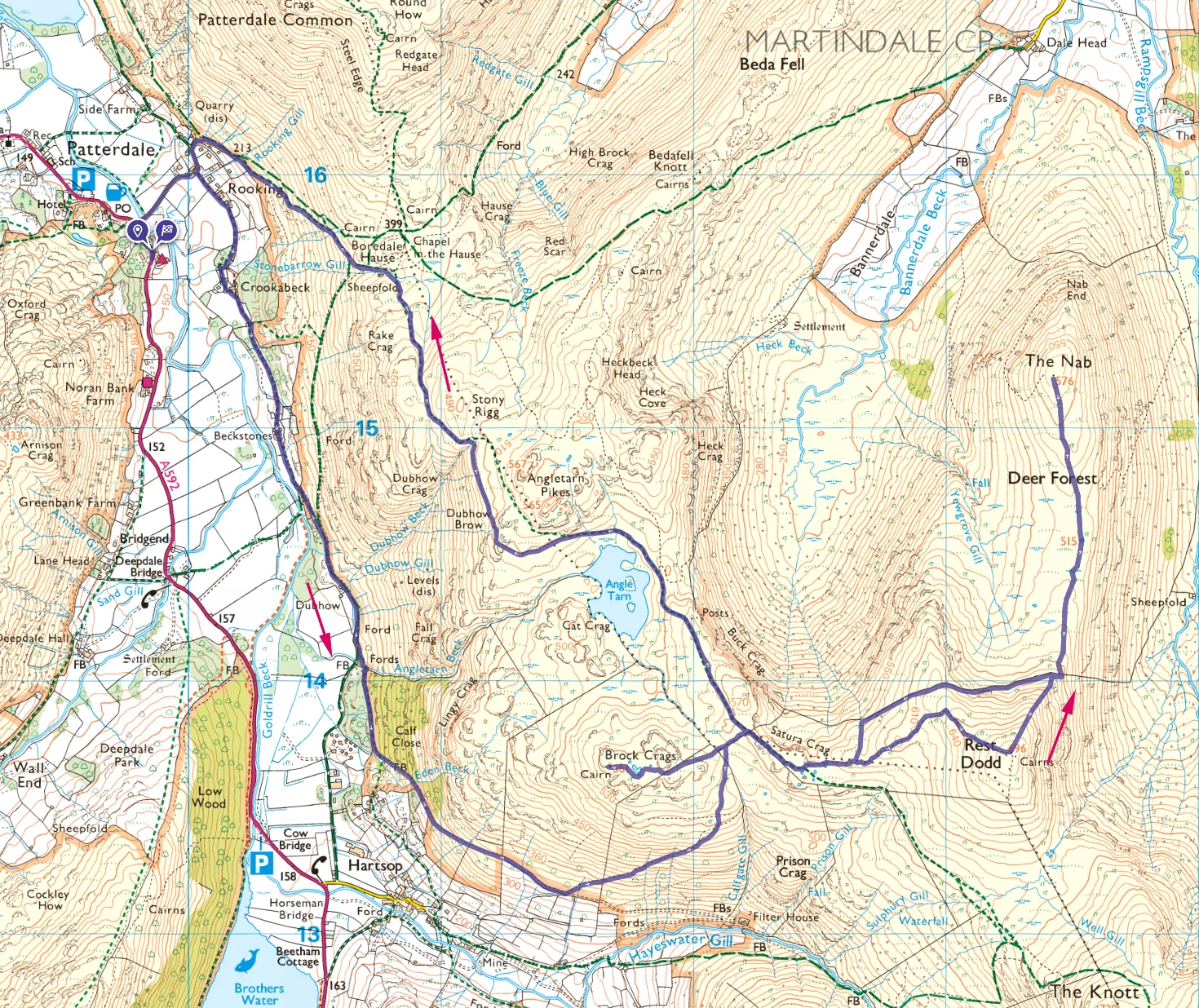
I spent Monday in Southport with Mum and left early on Tuesday morning, driving north up the M6 to Penrith and then via Pooley Bridge to park up as St. Peter’s church. It’s a location I know well, and an excellent place to start a walk. I arrived around 10am and the weather was looking “changeable”. If I was lucky, there would be some dramatic skies to photograph.

The last time I climbed Place Fell was with Tills. We slogged up what is probably referred to as the tourist route from Patterdale. I didn’t want to repeat that, so this time I was approaching from the north.

Unusually, this walk begins with a downhill section to the crossing of Sandwick Beck at Bridge End, before starting the gentle uphill route across the western slopes of Place Fell. The weather was looking doubtful and there were several light showers as I made my way around High Dodd.

By the time I reached the remnants of a small building at the disused quarry under High Dodd, there were enough blue breaks in the cloud to provide encouragement. A crossroads of several paths at Low Moss, centred on a lonely sheepfold made for an interesting place to pause before starting the steep-ish uphill section of the walk.

The summit at Place Fell is quite spectacular and probably one of the most notable OS triangulation columns in the district, being perched precariously on a rock outcrop with only just enough space to stand beside it. Although Place Fell is relatively modest in height, it is ideally placed for excellent 360 degree views with the Helvellyn range to the west, High Street to the east, Ullswater to the north and the Kirkstone pass to the south. Mark Richards describes it as “one of the most satisfying summits in Lakeland, both in its immediate visual appeal and in its outlooks”.

Satisfying indeed, and it was lovely to spend a little time there with just a couple of other walkers. At my last visit, on a warm sunny day, the place was buzzing with lunchtime activity with maybe thirty others.
After a short break, it was downhill to Boredale Hause, another busy junction of paths. On the way, the sky to the south became very dramatic as “weather” rolled in and rain looked imminent.

I was hoping to get a good replacement summit photo for Angletarn Pikes but the rather nondescript summit and the weather conspired to make that impossible. There is no cairn, just some exposed rock and scuffed grass. It’s one of those fell tops that looks much better from a distance than it does when you’re there. It was now 2.30pm and I’d been walking for around four hours.

I didn’t spend any time at Angletarn Pikes. On a future visit, I’ll check out the southern (lower) summit but right now I thought I might get a soaking, so I headed off smartly towards the Beda Fell ridge. With the wind now at my back, a light rain began to fall but, fortunately, it didn’t amount to much.
About an hour later I was at Beda Head, another disappointing summit. There was still rain in the air but this was made up for by more dramatic cloudscapes to the south.

I arrived back at the car at around 5 o’clock, happy that I’d easily completed the first walk of the week and that I hadn’t got too wet.
I drove to Patterdale and checked in to the YHA. Once unpacked, I walked round to the White Lion and had a supper of Cumberland sausage and mash. The portions were massive and I failed to clean my plate. An excellent end to the day. I was keeping my fingers crossed that tomorrows forecast might be wrong – heavy rain was predicted all morning.
Wednesday
The weather forecast was not wrong. I woke to a steady rain. Fortunately, I had a Plan B. I’d been wanting to visit the Errington Reay pottery near Hexham for some time, so this morning provided a good opportunity. It was about an hour away and I was hoping that by the time I’d been there and back, the rain might have passed. While I was in that neck of the woods, I thought I might visit Hadrian’s Wall, weather permitting.
There was plenty of activity at the pottery when I arrived and all the staff were very friendly. I was given access to the storage area where their lovely salt-glazed pots were kept and invited to take my pick. I had intended to buy just a large planter but couldn’t help coming away with a low bowl too. Without prompting, I was given a discount on the two pots. A very pleasing outcome from a rainy morning.

After visiting the pottery, I drove to The Sill visitor centre. Despite the weather, which was now dry but overcast, the place was busy. After looking at a small exhibition, I walked out to the wall and walked along it for about a mile before heading back. I have to admit that it was more impressive than I had expected. In places, there is plenty of the wall and associated structures still to see and it’s not difficult to imagine what it might have been like for the Roman soldiers stationed there.

I drove back to Cumbria, stopping off at Booths in Penrith for provisions. I then made my way back to St. Peter’s church and made a quick grab of Hallin Fell. The landscape had dried a little after the overnight soaking but the sky was still a steely grey.
Later, at YHA Patterdale, I enjoyed a lovely Korma curry for supper, courtesy of Booths.
Thursday (a haunting)
I don’t believe in the supernatural. My views are firmly in the humanist camp, but occasionally, crazy coincidence leaves space for second thoughts. At the end of this day, I was left wondering what on Earth was going on.

For the third day in a row, I parked up at St. Peter’s church (that’s not the coincidence). Today I was attempting a Fusedale round, taking in five Wainwrights. The weather was still looking grey but the forecast was for improving conditions as the day went on.

The day started pretty much like any other fellwalking day. After parking up, I set off in search of the first peak of the day. Steel Knotts is a nice, easy win and it’s always good to tick off the first Wainwright of the day soon after starting. Looking back during the climb, there was a great view of Hallin Fell, where I’d been the previous day. I was taking things slowly but was at Pikeawassa in under 40 minutes. Despite the fact that there were plenty of cars in the car park, I had the summit to myself.
This is a good summit to spend time at but I was keen to continue on what was one of the longer walks of the week. I headed off along the ridge towards Browntwaite Crag. The path swings north to some derelict buildings, under Gowk Hill before starting the steep ascent to the High Street ridge. This is the toughest section of the walk and I took my time.

Eventually, I reached the ridge path (or paths, there is a confusion of them), and turned left towards Wether Hill summit. The summit is easily missed, not being on the main path and consisting only of a small cairn and a boundary stone. It’s not even clear that it is the highest point as all around is pretty much flat.
Having broken the back of this walk, I sat down to rest a few metres from the cairn, in case some other fell baggers might need access. There’s no obvious place to sit, so I sat on the grass with a good view of the cairn and the lovely Helvellyn range as a backdrop.

I was enjoying the scene when, all of a sudden, three people, two men and a woman, appeared as if from nowhere. All three of them, ignoring me, walked over to the cairn and dumped their bags at the highest point, leaving them there for the duration of their stay. At this point, I hadn’t taken my customary photograph of the cairn. The light was improving and I was waiting until my departure. Now I’d have to wait for my thoughtless companions to leave.

After a lot of stomping about and stretching, the trio headed off north, taking their bags with them. I waited a while longer, giving them a head start and hoping that would be the last I’d see of them (that was wishful thinking).
I made my way to the third Wainwright of the day, Loadpot Hill. Although this fell is similarly flat-topped, the highest point is marked with a large OS trig column. As I approached, I could see the same three sitting at the base of the trig column, having their lunch. On arrival I made a point of tapping the top of the column, to the obvious irritation of the three. I then tried to photograph the summit but the woman complained and I had to move away without my prize.

At this point I was just annoyed by their behaviour and lack of etiquette. I assumed, that I’d now be free of them as I headed off towards Arthur’s Pike. I set a good pace, trying to create as much distance from the three as I could. By the time I reached the summit, there was no sign of them following, the cloud was breaking and the views over Ullswater were looking lovely.
One of the things I had most been looking forward to on this walk was to revisit the lonely sheepfold at Swath Beck. It’s an idyllic location, nestled between Bonscale Pike and Arthur’s Pike, and I’d planned to sit there and have my lunch, listening to the skylarks.

I set off down to Swarth Beck, but as I got closer to my destination, I could make out three figures sitting at my chosen lunchtime spot. As I got closer still, I recognised the trio, who looked settled in for the afternoon. All three were smoking and talking loudly, presumably the sound of the babbling beck and the birdsong was making life difficult for them. I felt completely thwarted and passed by without stopping.

It was after 2pm when I arrived at Bonscale Pike. I sat down and ate my lunch, expecting my tormentors to arrive at any minute and destroy the peace. Fortunately, I had the place to myself for the duration of my visit. My fifth Wainwright of the day was a lovely spot to be and I spent some time exploring, photographing the towers and taking in the amazing views down to Ullswater.

Eventually, I set off along the ridge to White Knotts, before taking the steep path down to Mellguards. From there, I made my way back to St. Peter’s church via Howtown. It was now a lovely day with just a few fluffy clouds against a deep blue sky.
From Mardale, I drove back along the Ullswater shore road. It was busy and the shoreside camp sites were just about full. As I approached Pooley Bridge, three characters stepped out in front of me and I had to break to avoid hitting them. I was totally amazed to see that it was the same trio who had haunted my walk. How come they were here too? What kind of malign force was at work?

Back at YHA Patterdale, I thought about the day and reasoned that I was simply a victim of some bizarre coincidence, but I couldn’t help doubting that explanation.
It was a very busy evening in the small self-catering kitchen and after waiting 45 minutes for an opportunity to stake my claim to a microwave, I lost patience and walked to the White Lion for gammon and chips. What a very strange day!
Friday
Although there was still plenty of cloud in the sky, it was warmer than on previous days with plenty of breaks in the cloud. I set off, leaving the hostel before 9am, looking forward to another productive day on the fells and hoping that I would mostly be left alone.
On my previous visit to the Lakes, in Spring 2022, I’d struggled a bit with fitness. Covid seemed to have a lasting effect. But this week, things seemed much better and I didn’t feel in need of a rest day. Today would be a no-drive day, I’d be walking out of and returning to YHA Patterdale on foot, a relative luxury.

Usually, I plan these walks carefully using the OS Maps app, but on this occasion, I felt I knew the lie of the land sufficiently well to just head out with the map as a guide. I was aiming to mop up some awkward customers – fells that don’t naturally form part of a circular walk. Certainly, Brock Crags and especially The Nab fall into that category so it seemed sensible to attempt them both in a single walk.

I crossed Goldrill Beck and walked south along the eastern path of the valley towards Hartsop. I don’t think I’d walked this path before and it was a rather lovely two and a half kilometres of gentle strolling in the soft, early morning light. Eventually, the path passes through woodland at Calf Close, after which it begins to rise around the base of Brock Crags.
As the woodland melted away, there were excellent views to the south, first of Hartsop Dodd, then into Pasture Beck and finally of Gray Crag with a glimpse of Hayeswater.

About half way up the southern flank of Brock Crags it looked like there may be a more direct route to the summit. For too long I dithered, eventually deciding that I didn’t need to risk it and continued on the well-trodden path. Eventually, I reached the saddle between Brock Crags and Satura Crag and was in familiar territory. A few minutes later I was at Brock Crags summit and grateful to find that I had the place to myself. It’s a very pleasant summit with a satisfying cairn and good views.

It had taken me three hours to reach my first Wainwright of the day, so I rested for a while, taking 15 minutes to have a drink and a muesli bar. Light and shadow over Angle Tarn looked fantastic and I could easily have spent the day there.
I retraced my steps to the saddle and then took the path across Satura Crag to Rest Dodd, by far the best way to approach this top. Last time I came up the southern slope, which was a real slog. Forty minutes after leaving Brock Crags, I was at Rest Dodd summit.

From Rest Dodd, it’s a steep drop to the north-east, across a hole in the wall and onto the long tongue-like ridge of The Nab. Although there are paths on the flanks of the Nab, the general consensus is that it should only be an out and back excursion of around two and a half kilometres across often tricky peat hag terrain.

I arrived at the rather disappointing summit at around half past one and although there is no obvious place to sit, I found a soft spot on the grass and ate my lunch. There is certainly a good sense of isolation at this spot. No one other than a Wainwright bagger is likely to come anywhere near.

After lunch I trudged back to the wall at Rest Dodd and followed it west, back to Satura Crag. It’s an awkward walk but once I’d passed through the gateway as Satura Crag, I knew that all the difficult parts of the walk were behind me.
On the way back, I determined to spend some time at Angle Tarn. It was still early in the afternoon and the weather was calm although not sunny. I arrived just before three o’clock and spent half an hour sitting beside the water.

An hour later I was back in Patterdale drinking a wonderful pint of bitter shandy at the Old Water View B&B, just along from the hostel. It was a fantastic way to finish a lovely, peaceful day.
That evening I had no problem finding a slot in the kitchen, despite the fact that there were plenty arriving for the bank holiday weekend.
Saturday
Today I’d be walking with Rob and, as is now our custom, we’d arranged to meet early for an alfresco breakfast of sausage baps, cooked on Rob’s camping stove. We met up at Peter House Farm. We’d planned to meet at 8am but I arrived around 7.30am only to find Rob already waiting. There was also a refreshment point for some run or other setting up. Just as well we arrived early as there wasn’t much space left!

The weather didn’t look promising – there was a lot of low cloud but after a lovely breakfast, we set off down the road, back the way we’d driven in. As we walked, the cloud began to break and light spilled through.

This is a walk I’d done before, so I was familiar with the route. It’s by far the best way to the summit at Skiddaw and I thought Rob might enjoy it. Unfortunately, Tom was unable to join us on this occasion.
It’s good to get any road walking out of the way ealy in a walk and after 2km we left the road and started uphill. By 8.30am we were making good progress and the sky was brightening. The forecast was for improving conditions as the day went on, so I wasn’t too concerned when we caught our first glimpse of Skiddaw, shrouded in cloud.

We made our way up what I think is one of the best ridges in Lakeland, taking in Ullock Pike, Long Side, and terminating at Carl Side. We’d started early and we were not in a hurry so we took it easy. In fact, we took it slowly because we could both see that the longer we took, the better the weather would be. Neither of us wanted to arrive at Skiddaw summit and not be able to see anything.

As we ascended The Edge, light wispy cloud played over the top of Ullock Pike but by the time we arrived there, it had all gone and we had excellent views. The same was true of Long Side and it felt as though we’d timed our walk perfectly, having the advantage of dramatic cloudscapes on the approach and then clear summits on arrival.
We got to Carl Side at a quarter to twelve and decided that the view over Keswick and Derwentwater was so good that we should sit and have an early lunch before attempting the tricky scree path to Skiddaw top. The weather was warming and we even had some blue sky overhead.

After a very pleasant lunch, we dropped down to the saddle and commenced the climb. It’s by far the toughest part of the walk and there was plenty of stopping to look at the view. After a lot of huffing and puffing, we arrived at the trig point at one thirty. There was a check point team for the runners and plenty of activity as usual.
After a short pause, I asked Rob if he’d like to make an out and back grab for Skiddaw Little Man. The answer was a definitive “no”. I think he’d found the drag up to the top a little tough and was enjoying the idea of it all being downhill from here. So we continued north to Bakestall.

Before the main drop down to Bakestall, there’s an odd plateau area where the path disappears and the ground is covered in broken shale. It feels as though it may be the result of quarrying, but there is no evidence of industrial activity – perhaps it’s just a topographical anomaly.
From there, it’s a relatively steep grassy drop down to Bakestall and then an even steeper drop along Birkett Edge to the Cumbria Way path. Once there, it’s a gentle stroll under Dead Crags and back to the cars at Peter House Farm. We finished the walk around four thirty and took a little while to change boots and get a drink.

Once we felt up to it, we drove to the Sun Inn at Bassenthwaite for a refreshing pint of shandy and a well-earned fish and chip supper. Rob had Scampi and I had Cod.
It had been a very good day. After supper I drove back to YHA Patterdale and Rob drove home. So far it had been a pretty productive week and, despite the changeable weather, I hadn’t had a real soaking.
Sunday
My last day in the Lake District for 2022 would be a short one. I had to drive back to Hampshire so I didn’t want to leave late. I figured that a single Wainwright would be a good idea and Dodd fitted that plan.
I checked out of YHA Patterdale, making a mental note to book YHA Ambleside next time. Patterdale is in a great location but is in need of some serious refurbishment. My room had the scars of the many previous alterations and was not looking good. I am not surprised that, at the time of writing (August 2023), YHA Patterdale is now up for sale. Presumably, YHA realise the need for refurbishment but are unable to afford the cost. This is a real shame and I can only hope that it is bought by a benevolent organisation.
I drove north into Keswick and stopped off at Booths to stock up on cordial – Booths has by far the best selection of drinks that I know of. From there, I drove to Dodd Wood car park and set off along forest tracks. There was plenty of cloud in the sky but it was still bright and dry.

Last time I did this walk, the main track was close because of forestry work. This time all the tracks were open and I took the longer, circuitous route to the summit. It’s an interesting walk, sometimes enclosed and sometimes with open views across Derwentwater.
After about an hour, I reached the summit and was able to get a much better photograph of the memorial stone than I had from my first visit. My timing was good, I had the summit to myself for about 10 minutes before a stream of other walkers arrived. These lower fells are prime targets for casual Sunday walkers, especially on a bank holiday weekend. On this occasion, I was happy to see so many other people enjoying the landscape.

I returned to the car and changed shoes. I paused for a while before setting off and had an early lunch. I always feel a little sad on the last day of my August visits, knowing it will likely be eight months before I return, during which time there is another cohort of students to be guided through a programme of study in web design. I enjoy my work but I miss the Lake District during the winter months.∗
23rd August 2022
A Boredale Round
Place Fell
Angletarn Pikes
Beda Fell
24th August 2022
Hallin Fell
25th August 2022
A Fusedale Round
Steel Knotts
Werther Hill
Loadpot Hill
Arthur’s Pike
Bonscale Pike
26th August 2022
Brock Crags
Rest Dodd
The Nab
27th August 2022
A Skiddaw Round
Ullock Pike
Long Side
Carl Side
Skiddaw
Bakestall
28th August 2022
Dodd
Kit notes
Many of the photographs taken on this trip were taken with the Sony A6500 plus a new lens that I bought in June 2022. The Tamron 11-20mm is an excellent lens for landscape photography and provides the wider field of view that I sometimes wish the Sony 16-55mm had. Prior to this lens being released in 2021, there was nothing on the market that wouldn’t have been a significant compromise in terms of image quality. So I’m thinking that this may become my primary walking lens. One further benefit is that it’s smaller and lighter than the Sony lens and that is some compensation for the fact that the A6500 is significantly heavier than the NEX-6.
Tagged: Lake District, Wainwrights, walking