The Southern Fells area is bounded in the west by Wast Water and in the east by Windemere. It extends north as far as Stonethwaite in Borrowdale and south to Coniston. The Southern Fells includes the highest peaks in the Lake District, including Scafell Pike, the highest mountain in England. The area includes 30 Wainwrights, which are described in Book Four of Alfred Wainwright’s Walking Guide to the Lake District Fells plus 15 fells described in the Fellranger guides, giving a total of 45.
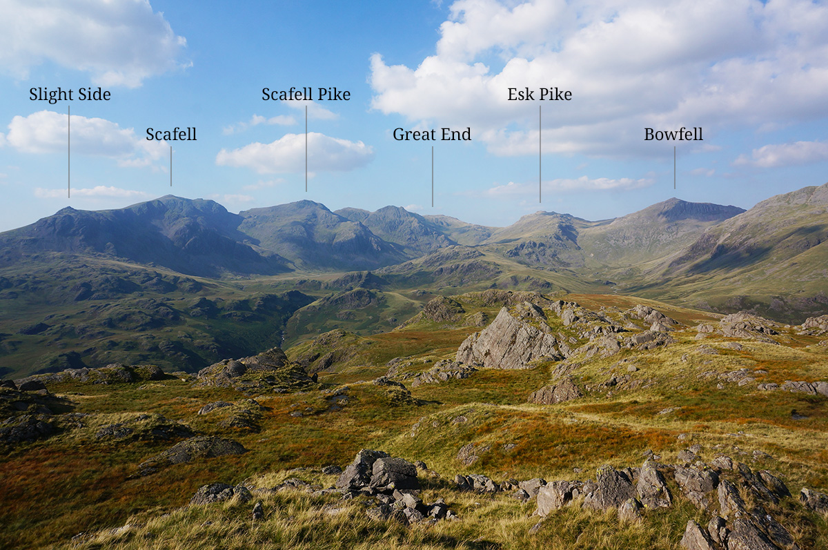
The image above shows the view north from the summit of Hard Knott towards the Scafell Massif. Six Wainwrights of the Southern Fells can be seen in the view (from left to right) Slight Side, Scafell, Scafell Pike, Great End, Esk Pike and Bowfell. Photo taken 31st August 2018.
Map of the Southern Fells
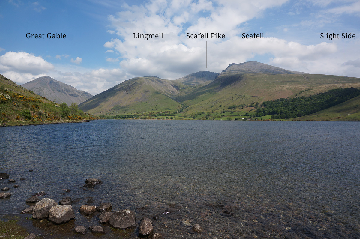
The image above shows the view east from the Wast Water lake shore road towards the Scafell Massif. Four Wainwrights of the Southern Fells can be seen in the view (from left to right) Lingmell, Scafell Pike, Scafell and Slight Side (just peeping above Green How). Great Gable falls into the Western Fells. Photo taken 22nd May 2017.
The Southern Fells
| Fell name | Height | Bagged | Dates |
|---|---|---|---|
| Allen Crags * | 785m |  | 26/07/2018 16/05/2025 |
| Black Fell | 323m |  | 20/05/2017 01/08/2024 |
| Bowfell * | 902m |  | 25/07/2018 14/08/2020 |
| Brim Fell | 796m |  | 29/08/2018 28/06/2024 |
| Cold Pike * | 701m |  | 25/07/2018 30/07/2024 |
| Coniston Old Man | 803m |  | 29/08/2018 28/06/2024 |
| Crinkle Crags * | 859m |  | 25/07/2018 14/08/2020 |
| Dow Crag | 778m |  | 29/08/2018 28/06/2024 |
| Esk Pike * | 885m |  | 25/07/2018 28/06/2026 |
| Glaramara * | 783m |  | 28/08/2018 16/05/2025 |
| Great Carrs | 785m |  | 29/08/2018 25/06/2024 |
| Great End * | 910m |  | 26/07/2018 02/07/2026 |
| Green Crag | 489m |  | 31/08/2018 29/06/2026 |
| Grey Friar | 770m |  | 29/08/2018 25/06/2024 |
| Hard Knott * | 549m |  | 31/08/2018 29/06/2026 |
| Harter Fell | 654m |  | 31/08/2018 29/06/2026 |
| Holme Fell | 317m |  | 21/05/2017 29/08/2021 |
| Illgill Head * | 609m |  | 22/05/2017 22/04/2026 |
| Lingmell * | 800m |  | 14/06/2019 02/07/2026 |
| Lingmoor Fell * | 469m |  | 20/05/2017 22/08/2023 |
| Pike o'Blisco * | 705m |  | 03/08/2017 01/08/2024 |
| Rossett Pike * | 651m |  | 25/07/2018 28/06.2026 |
| Rosthwaite Fell (Bessyboot) * | 551m |  | 28/08/2018 15/05/2025 |
| Scafell * | 964m | | 15/06/2019 26/05/2023 |
| Scafell Pike * | 978m |  | 14/06/2019 02/07/2026 |
| Seathwaite Fell * | 632m |  | 28/07/2018 29/07/2024 |
| Slight Side * | 762m | | 15/04/2019 26/05/2023 |
| Swirl How | 802m |  | 29/08/2018 25/06/2024 |
| Wetherlam | 763m |  | 04/08/2017 25/06/2024 |
| Whin Rigg * | 535m |  | 22/05/2017 22/04/2026 |
* Appears in the Fellranger guide to the Mid-Western Fells.
The Wainwright Southern Fells are divided between two of Mark Richards’ first edition Fellranger guides; the Southern Fells and the Mid-Western Fells. Those that appear in the Fellranger guide to the Mid-Western Fells are marked with an asterisk, the remainder appear in the Fellranger guide to the Southern Fells.
References
The details in the table above are taken from various sources but most notably:
The Mid-Western Fells (Lakeland Fellranger guide) by Mark Richards
The Southern Fells (Lakeland Fellranger guide, 1st edition) by Mark Richards
The Southern Fells (Walkers Edition) by A. Wainwright and revised by Clive Hutchby
Walking the Wainwrights by Stuart Marshall
Lake District West (Superwalker XT25) by Harvey Maps