The Western Fells comprise two wedge-shaped mountain groups, those between Wast Water and Ennerdale Water, and those between Ennerdale Water and Buttermere/Crummock Water. The area includes 33 Wainwrights, which are described in Book Seven of Alfred Wainwright’s Walking Guide to the Lake District Fells and two additions from the Fellranger guide, making a total of 35.
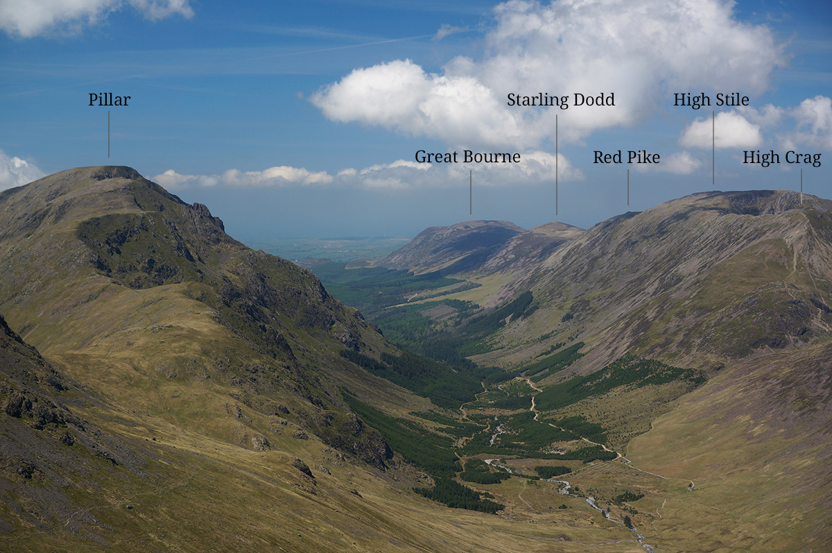
The photograph above shows the view from Green Gable summit towards Ennerdale, which cuts through the Western Fells, east to west. It shows all the Wainwrights along the High Stile ridge, plus Pillar. Photo taken 23rd May 2018.
This section was completed on 8th July 2019 with the ascent of Haystacks. That summit also marked the completion of the whole round of 214 Wainwrights.
Map of the Western Fells
The Western Fells
| Fell name | Height | Bagged | Date (first) |
|---|---|---|---|
| Base Brown | 646m |  | 23/05/2018 29/07/2024 |
| Blake Fell | 573m |  | 22/05/2018 12/05/2025 |
| Brandreth | 715m |  | 23/05/2018 06/08/2025 |
| Buckbarrow | 430m |  | 20/04/2019 19/04/2026 |
| Burnbank Fell * | 475m |  | 22/05/2018 12/05/2025 |
| Caw Fell | 697m |  | 19/04/2019 21/04/2026 |
| Crag Fell | 523m |  | 19/04/2019 21/04/2026 |
| Fellbarrow | 416m |  | 10/06/2018 24/06/2024 |
| Fleetwith Pike | 648m |  | 08/07/2019 06/08/2025 |
| Gavel Fell | 526m |  | 22/05/2018 12/05/2025 |
| Great Borne | 616m |  | 30/08/2018 05/08/2025 |
| Great Gable | 899m |  | 23/05/2018 29/07/2024 |
| Green Gable | 801m |  | 23/05/2018 29/07/2024 |
| Grey Knotts | 697m |  | 23/05/2018 06/08/2025 |
| Grike | 488m |  | 21/04/2019 21/04/2026 |
| Haycock | 798m |  | 19/04/2019 21/04/2026 |
| Haystacks | 598m |  | 08/07/2019 06/08/2025 |
| Hen Combe | 509m |  | 22/05/2018 14/05/2025 |
| High Crag | 744m |  | 30/08/2018 24/08/2023 |
| High Stile | 807m |  | 30/08/2018 24/08/2023 |
| Kirk Fell | 802m |  | 24/04/2019 |
| Lank Rigg | 541m |  | 21/04/2019 21/04/2026 |
| Low Fell | 423m |  | 10/06/2018 24/06/2024 |
| Mellbreak | 512m |  | 22/05/2018 14/05/2025 |
| Middle Fell | 585m |  | 20/04/2019 19/04/2026 |
| Pillar | 892m |  | 23/04/2019 24/04/2026 |
| Red Pike (Buttermere) | 755m |  | 30/08/2018 24/08/2023 |
| Red Pike (Wasdale) | 828m |  | 23/04/2019 24/04/2026 |
| Scoat Fell | 843m |  | 23/04/2019 24/04/2026 |
| Seatallen | 693m |  | 20/04/2019 19/04/2026 |
| Starling Dodd | 635m |  | 30/08/2018 05/08/2025 |
| Steeple | 819m |  | 23/04/2019 24/04/2026 |
| Yewbarrow | 628m |  | 23/04/2019 24/04/2026 |
* Appears in the Wainwright guide to the Western Fells but not in the Fellranger guide.
Burnbank Fell is not included in Mark Richards’ Fellranger guides but it does get a mention in the chapter on Blake Fell. In that chapter, he says of Burnbank Fell: “…in one influential list this was deemed a separate fell, and you may wonder why”.
References
The details in the table above are taken from various sources but most notably:
The Western Fells (Lakeland Fellranger guide, 1st edition) by Mark Richards
The Western Fells (2nd edition) by A. Wainwright and revised by Chris Jesty.
Lake District West (Superwalker XT25) by Harvey Maps