This is the third section of fells, which I started on 24th August 2016 and is described in Book Two of Alfred Wainwright’s Walking Guide to the Lake District Fells. It includes the area to the east of Ullswater, Windemere and the Kirkstone Pass. The area includes 36 Wainwrights and is 18km from Arthur’s Pike in the north to Sour Howes in the south.
The section was completed on 19th May 2017 with a visit to Wansfell during the Troutbeck Medley walk.
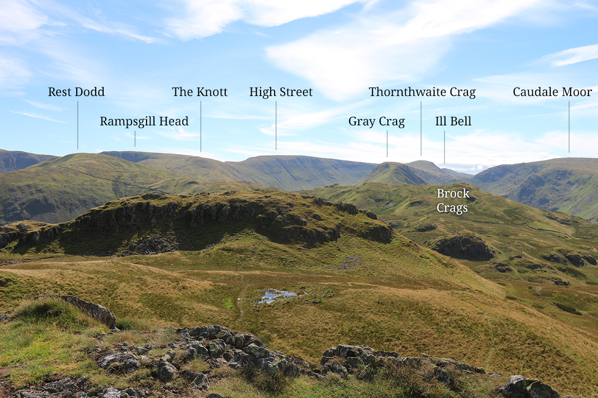
The image above shows the view south-east from Angletarn Pikes. Nine Wainwrights can be seen in the view (from left to right) Rest Dodd, Rampsgill Head, The Knott, High Street, Gray Crag, Thornthwaite Crag, Ill Bell, Brock Crags and Caudale Moor. The crag in the foreground is the east peak of Angletarn Pikes. Photo taken 24th August 2016.
Map of the Far Eastern Fells
The Far Eastern Fells
| Fell name | Height | Bagged | Dates |
|---|---|---|---|
| Angletarn Pikes | 567m |  | 24/08/2016 23/08/2022 |
| Arthur's Pike | 533m |  | 10/04/2017 25/08/2022 |
| Beda Fell | 509m |  | 13/04/2017 23/08/2022 |
| Bonscale Pike | 529m |  | 10/04/2017 25/08/2022 |
| Branstree | 713m |  | 12/05/2017 23/04/2023 |
| Brock Crags | 561m |  | 13/04/2017 26/08/2022 |
| Caudale Moor | 764m |  | 13/05/2017 27/04/2023 |
| Froswick | 720m |  | 14/05/2017 20/08/2023 |
| Gray Crag | 697m |  | 13/05/2017 27/04/2023 |
| Grey Crag | 638m |  | 12/05/2017 18/08/2023 |
| Hallin Fell | 388m |  | 17/10/2016 24/08/2022 |
| Harter Fell | 778m |  | 14/05/2017 23/04/2023 |
| Hartsop Dodd | 618m |  | 13/05/2017 27/04/2023 |
| High Rise | 802m |  | 13/04/2017 27/08/2021 |
| High Street | 828m |  | 14/05/2017 27/08/2021 |
| Ill Bell | 757m |  | 14/05/2017 20/08/2023 |
| Kentmere Pike | 730m |  | 14/05/2017 20/08/2023 |
| Kidsty Pike | 780m |  | 13/04/2017 27/08/2021 |
| Loadpot Hill | 671m |  | 10/04/2017 25/08/2022 |
| Mardale Ill Bell | 761m |  | 14/05/2017 20/08/2023 |
| Place Fell | 657m |  | 24/08/2016 23/08/2022 |
| Rampsgill Head | 792m |  | 13/04/2017 27/08/2021 |
| Rest Dodd | 697m |  | 13/04/2017 26/08/2022 |
| Sallows | 516m |  | 19/05/2017 26/04/2022 |
| Selside Pike | 655m |  | 12/05/2017 23/04/2023 |
| Shipman Knotts | 587m |  | 14/05/2017 20/08/2023 |
| Sour Howes * | 483m |  | 19/05/2017 26/04/2022 |
| Steel Knotts | 433m |  | 17/10/2016 25/08/2022 |
| Tarn Crag | 664m |  | 12/05/2017 18/08/2023 |
| The Knott * | 739m |  | 13/04/2017 27/08/2021 |
| The Nab * | 576m |  | 13/04/2017 26/08/2022 |
| Thornthwaite Crag | 784m |  | 13/05/2017 27/04/2023 |
| Troutbeck Tongue | 363m |  | 19/05/2017 28/04/2023 |
| Wansfell | 489m |  | 19/05/2017 24/04/2023 |
| Wether Hill | 673m |  | 10/04/2017 25/08/2022 |
| Yoke | 706m |  | 14/05/2017 20/08/2023 |
* Appears in the Wainwright guide to the Far Eastern Fells but not in the Fellranger guide.
Sour Howes, The Knott and The Nab do not merit a separate chapter in Mark Richards’ Fellranger guide. However, The Nab is covered in the chapter for Rest Dodd, The Knott gets a brief mention in the Rampsgill Head chapter and Sour Howes, a similarly brief mention in the Sallows chapter. All three are included in AW’s guide to the Far Eastern Fells.
References
The details in the table above are taken from various sources but most notably:
The Far Eastern Fells (Lakeland Fellranger guide, 1st edition) by Mark Richards
The Far Eastern Fells (Walkers edition) by A. Wainwright and revised by Clive Hutchby
Walking the Wainwrights by Stuart Marshall
Lake District East (Superwalker XT25) by Harvey Maps